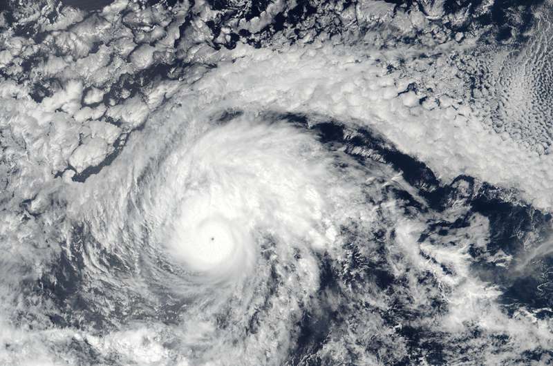
Credit: NOAA/NASA Goddard MODIS Rapid Response Team
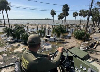
On the morning of Wednesday, October 25, 2023, Hurricane Otis, a Category 5 storm, devastated Mexico’s southern Pacific coast. The hurricane caused significant damages to the tourist hub of Acapulco.
In the immediate aftermath of the storm, landslides and downed power lines caused significant interruptions to transportation networks and mobile connectivity across the Guerrero state on Mexico’s Pacific Coast.
By midmorning on October 25, Otis had been downgraded to a tropical storm. Despite the storm’s decreased severity, the aftermath has left coastal residents in shock.
ReadyReports & Data Updates
Monday, November 27, 2023
Acapulco, Guerrero State, Mexico (Pacific Coast)
This situation report on Hurricane Otis in Acapulco, Mexico shows the relationship between damage assessment data with changes in population densities. The combined data reveals insights on the long-term impacts of the hurricane in the areas of greatest impact.
The damage assessment data was produced by Google SKAI. The population data was produced by WorldPop.
Acapulco, Guerrero State, Mexico (Pacific Coast)
This situation report shows the relationship between damage assessment data with healthcare facility data in Acapulco. The data shows that 29 out of 77 total healthcare facilities (38%) are marked as having ‘Major Damage,’ while some are marked as being ‘Destroyed.’
Thursday, October 26, 2023
Southwestern Mexico (Pacific Coast) | 17:00 CST
These reports, provided in Spanish and English, include information on the disaster perimeter of Hurricane Otis in Mexico, as well as baseline community vulnerabilities and population movement (as measured by changes in population densities).
Key Observations
Signal Loss
- Acapulco de Juarez experienced a signal loss of 97%.
- Copala experienced a signal loss of 97%.
- San Marcos experienced a signal loss of 92%.
Decreases in Population Densities
- Between October 24th to 26th, eleven administrative units had drastic shifts in population measurements:
- Ometepec
- Igualapa
- Atoyas de Alavarez
- Coyuca de Benitez
- Benito Juarez
- Illiatenco
- Tecpan de Galeana
- Santo Maria Cortijo
- Santiago Llano Grande
- San Juan Bautista Lo de Soto
- Mortires de Tacubaye
- These shifts ranged from decreases of 80% or less to numbers near or above baseline.
Increases in Population Densities
- Tecpan de Galeana had a population increase of 10%.
- Petatlan had a population increase of 9%.
- Chilpancingo de los Bravo had a population increase of 6%.
- This city also saw an increase of 3325 Facebook users between October 25th and 26th and is likely receiving displaced populations.
- Huitzuco de los Figueroa had a population increase of 6%.
Wednesday, October 25, 2023
Southwestern Mexico (Pacific Coast) | 17:00 CST
These reports, provided in Spanish and English, include information on the disaster perimeter of Hurricane Otis in Mexico, as well as baseline community vulnerabilities and population movement (as measured by changes in population densities).
Key Observations
Signal Loss
- Hurricane Otis caused catastrophic infrastructure damage, leading to a near-total signal loss in many areas around the storm’s path
- Areas with over 90% population decrease are likely due to massive network and electrical infrastructure outages, not necessarily population movements.
Decreases in Population Densities
- Seven coastal communities near Acapulco experienced significant population decreases:
- Acapulco de Juárez: -99%
- Atoyac de Álvarez: -90%
- Tecpan de Galeana: -92%
- Benito Juárez: -90%
- San Luis Acatlán: -94%
- Ayutla de los Libres: -98%
- Copala: -98%
Increases in Population Densities
- Few major population centers saw an increase in population. Notable areas with over 4,000 Facebook users that had increases included:
- Coyuca de Catalan: +6%
- Pungarabato: +4%
- Santiago Pinotepa Nacional: +4%
- Chilpancingo de los Bravo: +3%
Tuesday, October 24, 2023
Southwestern Mexico (Pacific Coast) | 17:00 CST
REPORT IN SPANISH
This report provides information on the disaster perimeter of Hurricane Otis in Mexico, as well as baseline community vulnerabilities and population movement (as measured by changes in population densities).
Key Observations
Decreases in Population Densities
- Little evidence of significant population movement away from coastal areas just before Hurricane Otis made landfall.
- Exceptions include communities to the southeast of Acapulco, including Copala, Florencio Villarreal, Marquelia, Juchitán, and Cuautepec, which experienced a population declines between -5% and -15% compared to a 90-day pre-disaster baseline.
- The southeastern side of Acapulco recorded population reductions greater than -10% in several locations.
- Other areas of Acapulco, apart from the southeastern side, remained largely unchanged in terms of population density.
Population & Community Information
- Acapulco’s population is generally younger compared to surrounding areas.
- 9% of Acapulco’s population is over 60, compared to 11% – 12% in Cautepec and Copala.