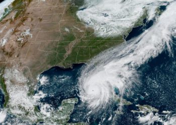
CrisisReady is aiding the response to Hurricane Idalia by producing situation reports that track changes in population densities, highlighting displacement in affected areas of Florida. These reports also provide data on baseline population vulnerabilities and local healthcare infrastructure, including facilities, outpatient centers, and hospitals.
The reports can be accessed below.
Data Updates
Sunday, September 3, 2023
Northwest Florida, United States | 19:00 EDT (7:00 p.m. local time)
This report provides data on population density changes in Florida as of Sunday, September 3, 2023 at 7:00 p.m. local time. The data provides insights to evolving patterns of population displacement as local and federal agencies respond to the disaster.
The report also provides information on baseline population vulnerabilities and the status of local healthcare infrastructure.
Communities in northwest Florida tend to have high rates of Facebook usage with location services, with most areas measuring 15% to 25% of total population, indicting relatively high levels of representativeness.
Key Observations
Overview of Population Density Changes
- On average, significant population displacement below -10% lasted from August 28th through September 1st, totaling 4 days.
- By the evening of September 3rd, most areas in the Big Bend region impacted by Hurricane Idalia returned to population baselines, signaling the end of the crisis event.
Decreases in Population Densities
- Although most densities have returned to baseline levels, some outliers persist. Hamilton County remains at -6% relative to baseline.
- Storm surge affected communities, particularly Steinhatchee and Crystal River, are nearing baseline but still exhibit reductions of -4% to -18%.
Thursday, August 31, 2023
Northwest Florida, United States | 19:00 EDT (7:00 p.m. local time)
This report provides data on population density changes in Florida as of Thursday, August 31, 2023 at 7:00 p.m. local time. The data provides insights to evolving patterns of population displacement as local and federal agencies respond to the disaster.
The report also provides information on baseline population vulnerabilities and the status of local healthcare infrastructure.
Communities in northwest Florida tend to have high rates of Facebook usage with location services, with most areas measuring 15% to 25% of total population, indicting relatively high levels of representativeness.
Key Observations
Population Density Changes
- Post-Hurricane Idalia landfall, major storm-impacted areas are significantly returning to their population baseline three days later.
- Eight counties still lie below their population baselines:
- Lafayette
- Jefferson
- Dixie
- Madison
- Franklin
- Suwanee
- Taylor
- Hamilton
- Despite the initial decreases, all eight counties mentioned above have shown population increases compared to figures from August 30th.
- Coastal communities severely hit by flooding—specifically Madison, Steinhatchee, Homosassa, and Crystal—are still experiencing over 20% decrease in population. However, each has seen a rise of at least 15% since August 30th.
Wednesday, August 30, 2023
Northwest Florida, United States | 19:00 EDT (7:00 p.m. local time)
This report provides data on population density changes in Florida as of Wednesday, August 30, 2023 at 7:00 p.m. local time. The data provides insights to evolving patterns of population displacement as local and federal agencies respond to the disaster.
The report also provides information on baseline population vulnerabilities and the status of local healthcare infrastructure.
Communities in northwest Florida tend to have high rates of Facebook usage with location services, with most areas measuring 15% to 25% of total population, indicting relatively high levels of representativeness.
Key Observations
Storm Update
- Idalia has been downgraded to category 1 as it progressed to Georgia and the Carolinas.
Decreases in Population Densities
- Drastic population declines noted in storm-affected areas during the time of analyses, with Suwanee County showing the most significant decline: -4% pre-storm to -43% post-storm.
- Counties with population decreases exceeding -10%:
- Lafayette
- Gulf
- Hamilton
- Jefferson
- Madison
- Dixie
- Franklin
- Taylor
- Coastal towns, which are facing storm surge flooding, are also experiencing high population declines. These include:
- Jasper
- Panacea
- St. George Island
- La Crosse
- Steinhatchee
- Perry
- Live Oak
- Monticello
- Crystal River
- Homosassa
Increases in Population Densities
- Counties with population increases between 5% to 10% include:
- Gadsen
- Leon
- Alachua
- Pasco
- Marion
- Hernando
- Cities showing population increases greater than 10%:
- Tallahassee: +12%
- Gainesville: +11%
- Note: Internal movement within these cities decreased, despite the overall growth.
Tuesday, August 29, 2023
Northwest Florida, United States | 19:00 EDT (7:00 p.m. local time)
This report provides data on population density changes in northern and central Florida as of 7:00 p.m. local time on Tuesday, August 29, 2023, the evening prior to Hurricane Idalia’s landfall. It highlights population displacement during the period evacuation orders were issued by state and county officials.
Additionally, the report provides information on baseline population vulnerabilities and the status of local healthcare infrastructure.
Key Observations
Counties with Population Decline Prior to Landfall
- Predominantly in the Big Bend and inland areas:
- Madison
- Suwanee
- Levy
- Lafayette
- Wakulla
- Echols
- Dixie
- Taylor
- Franklin
Counties with Significant Declines
- Coastal regions with declines 10% or more where evacuation orders were issued:
- Dixie
- Taylor
- Franklin
- Areas registering population drops of 45% or more before the storm:
- Panacea
- Steinhatchee
- St. Mark’s
- Crystal River
- Homosassa
- Note: Steinhatchee reported storm surge levels over 8 feet as of the morning of August 30th, indicating extreme risk.
Social Media Usage & Mobility Data
- Florida communities in the Big Bend area typically exhibit:
- High Facebook usage rates with location services (15%-25%).
- Consequently, a high degree of representativeness in mobility data.