Updated: Tuesday, September 12, 2023, 12:20 PM ET
A 6.8 magnitude earthquake struck near Marrakesh, Morocco on the evening of Friday, September 8 around 11 PM local time.
The epicenter was close to Marrakesh, leading many residents to sleep outside due to fear and causing damage to historic sites. According to data from the US Geological Survey, this quake was the most powerful to affect the Marrakesh area in over 120 years.
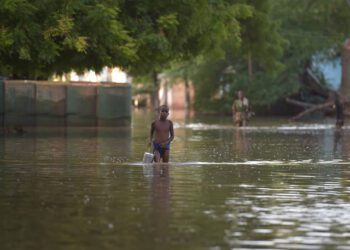
As of Tuesday, September 12, at least 2,901 individuals lost their lives, and another 5,530 were injured following the devastating earthquake. The government reported that a majority of the fatalities were trapped beneath the rubble of fallen structures. As rescue efforts continue, international response teams from Britain, Spain, and Qatar are assisting the Moroccan military. However, with each passing moment, reports state that the chances of discovering survivors diminish.
Amidst this tragedy, international aid organizations are highlighting the colossal challenge ahead for Morocco, both in assisting the approximately 300,000 impacted residents and in reconstructing the devastated communities.
News outlets have reported that UNICEF announced on Monday that approximately 100,000 children were affected by the earthquake in Morocco last Friday. While the exact number of child casualties remains uncertain, UNICEF highlighted that 2022 estimates showed children making up nearly one-third of Morocco’s population.
To aid response efforts, CrisisReady is producing data updates and reports, which aim to offer important insights for relief agencies.
Data Updates & Reports
Note: All reports can be found on CrisisReady’s organization page on ReliefWeb.
Tuesday, September 12, 2023
This report provides information on population density changes in the regions affected by the earthquake in Morocco. It also provides general information on the status of network connectivity in the area. Moreover, information on baseline community vulnerabilities and local healthcare infrastructure is provided.
Key Observations:
Increases in Population Densities:
- Four days after the earthquake struck Morocco, especially in the Atlas mountains region, Facebook user data showed increased population levels compared to pre-crisis baselines in most affected areas.
- As of September 12th, Marrakesh and Taroudant, two heavily impacted cities, recorded population increases of 33% and 45% above baseline, respectively.
- These population increases were consistent since the immediate aftermath of the earthquake.
Network Connectivity:
- Network connectivity remains notably low in the rural regions hit hardest by the earthquake.
- Due to this sparse connectivity, population estimates based on mobile application data in these rural areas may not be fully representative.
- In contrast, urban areas like Marrakesh and Taroudant have a high proportion of Facebook users. Users with location services on range between 10% and 20% of the total city populations.
- Public data aligns with these observations, estimating the Facebook user base in Morocco to be between 55% and 60%.
This report provides an integrated analysis of population density changes and network accessibility in Morocco as of Tuesday, September 12. It also delineates the perimeter or border of various severity zones in the impacted regions, ranging from severity level 6 to severity level 8 on the Richter scale. By distinguishing these zones, the map offers a clear visual representation of the areas most affected by the quake.
By overlaying these data sets on a map, the report offers a comprehensive understanding of evolving displacement dynamics and identifies areas where communication networks are most impacted. Such insights are crucial for coordinating effective response efforts and understanding the broader implications of the earthquakes on the affected communities.
Key Observations:
Increases in Population Densities:
- The hardest-hit regions of Morocco near the city of Marrakesh all showed significant increases in population densities at the time of analysis.
- Throughout the “strong” to “severe” shake areas (all those in severity levels 6 – 8), increases in population densities consistently measured between 25% – 100%, with minor and sporadic exceptions.
- These increases were mostly registered in the urban areas of Marrakesh and Taroudant, in part given to the unequal distribution of network bandwidth.
Network Connectivity:
- Active network connections remained sparse in most of the areas impacted by the quake.
- Network connections are most sparse in rural areas, especially those in the Atlas Mountain region.
This report provides network coverage maps in the regions affected by the earthquake in Morocco. The map indicates where Facebook users accessed 2G, 3G, or 4G connections on their mobile devices on Saturday, September 9, a day after the earthquake struck.
The coverage is determined from the type of cell sites users connect to when updating their Facebook app, not from telecommunication services. It reflects the estimated coverage and connection type based on user device reports.
Understanding mobile network coverage after the earthquake offers insights into the severity and scale of damage, thereby helping prioritize areas of response. Analyzing changes in connectivity helps gauge infrastructural impacts, indicating areas needing immediate intervention such as alternative communication systems. This data aids in optimizing resource deployment, understanding movement patterns, ensuring timely rescues, facilitating inter-agency coordination, and guiding long-term recovery.
Key Observation
- The report reveals that out of 2,527,304 people living in the severe shake zones, only about 531,070 have internet access. This suggests roughly 79% of individuals in these areas don’t have online connectivity.
Notes
- “Active Network access” means Facebook users who gave permission to use data and had cellular connectivity on September 9th.
- Colors indicate population size using HRSL data.
- Grey areas on the map show where Facebook users accessed Facebook, suggesting there’s some network connectivity. However, it doesn’t show how strong that connection is, even though it collected data ranging from 2G to 4G.
- The estimated number of users comes from population data in specific areas (from HRSL) and where they connected to Facebook on that date. This estimate doesn’t rely on reported outages from mobile companies.
- There might be inaccuracies in these estimates because of differences in the geographic analysis of both datasets.
- The 79% figure might not represent the actual decrease in connectivity after the earthquake, as we’re still waiting for baseline analyses.
Sunday, September 10, 2023
This report, using data from Meta’s Data for Good initiative, shows population densities in the areas of Morocco that were hardest hit by the recent earthquake. Population density is juxtaposed with the quake’s severity scale, which spans from 6 to 8.
The findings show that the regions with the highest population densities experienced a severity level of 6 during the quake on the evening of September 8. Conversely, the areas with severity level 8 had the fewest inhabitants.
Being provided with baseline population density metrics may help response agencies understand patterns of displacement and movement post-disaster in context, thereby providing a clearer picture of evacuations, potential shelter needs, and the redirection of resources to cater to newly concentrated populations.
This report uses data from Open Street Map (OSM) via the Humanitarian Data Exchange (HDX) to analyze healthcare facility density in earthquake-affected areas of Morocco.
The findings of the report reveal limited facility density, with exceptions in Marrakesh and Taroudant. OSM records show 5 hospitals, 3 clinics, and 750 pharmacies, none of which are located in the hardest-hit areas of the country.
Identifying healthcare facilities near the earthquake’s epicenter and in the hardest-hit regions of Morocco is crucial for gauging the disaster’s infrastructural damage as well as potential health hazards and impacts. Knowledge of the general landscape of these facilities can help response teams prioritize areas for medical aid, predicting potential health crises, and facilitating timely interventions.
Saturday, September 9, 2023
To provide deeper insights into the socio-economic impacts of the earthquakes in Morocco, this report employs Meta’s Relative Wealth Index (RWI). This tool showcases the distribution of wealth across the areas of the country most affected by the recent tremors.
Meta’s Relative Wealth Index (RWI) can be accessed here: https://dataforgood.facebook.com/dfg/tools/relative-wealth-index