Updated: Wednesday, August 16, 2023 at 10:15 AM EST
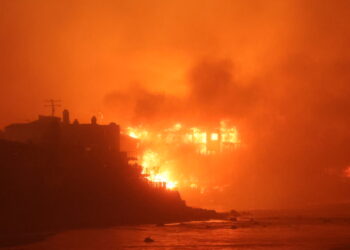
The death toll from the Maui wildfires has risen to 106, according to Maui County officials.
This update comes as new evidence, including a video showing a wooden power pole snapping and igniting a row of flames, suggests that fallen utility lines may have been the cause of the fire.
Hawaiian Electric Co. is facing criticism for not shutting off the power amid high wind warnings, a decision now cited in a class-action lawsuit seeking to hold the company responsible for the deaths. Despite these accusations, Hawaiian Electric declined to comment on the lawsuit. The company’s President and CEO, Shelee Kimura, noted that many factors, including the potential impact on those reliant on medical equipment and firefighters’ need for power to pump water, play into the decision to cut power.
Maui Police Chief John Pelletier expressed frustration at conflicting public complaints about both the lack of power shut-offs and the number of people unaccounted for due to disrupted communications.
Updated: Tuesday, August 15, 2023 at 4:19 PM EST
As of Tuesday, August 15, 2023, the wildfires in Maui, Hawaii have taken a devastating toll, with the confirmed death count rising to 99 people.
With only 25% of the burn area having been searched so far, officials are deeply concerned that this grim number will continue to climb. Authorities are bracing for the possibility that the death toll could potentially double over the next ten days as search and rescue operations persist. The number of people who remain unaccounted for is currently unclear, a situation that has been exacerbated by communication challenges.
According to a statement from Hawaii Governor Josh Green, many people were forced to flee rapidly from the advancing fires, leaving behind all their belongings, including their phones, which are now incinerated.
As of Monday, around 25% of the fire zone had been combed by search teams. Maui Police Chief John Pelletier expressed hope that 85% to 90% of the area will have been searched by the upcoming weekend.
CrisisReady is actively monitoring the Lahaina wildfires in Hawaii, generating periodic situation reports to track population displacement and assess local vulnerabilities and healthcare infrastructure. These insights guide emergency responses, helping to prioritize aid, allocate medical resources, and develop strategies that consider the interconnected challenges of the wildfires.
Data Updates
All CrisisReady data reports can be found on ReliefWeb.
Access data on CrisisReady’s open data portal here.
Tuesday, August 15, 2023
Hawaii | 18:00 CDT (7:00 p.m. local time)
This report provides information on population density changes registered on Tuesday, August 15 at 18:00 CDT (7:00 p.m. local time) in the regions of Hawaii most affected by the wildfires.*
The report also provides information on baseline community vulnerabilities and local health care infrastructure.
Key Observations
Death Toll & General Updates:
- The wildfires in Maui, Hawaii have caused 106 deaths.
- Rescue and identification efforts are ongoing.
- Upcountry/Kula fire is about 75% contained.
- Lahaina fire is 85% contained.
Decreases in Population Densities:
- Data shows ongoing decreases in population densities in Western Maui.
- Lahaina remains 91% decreased from baseline, but this may change as Lahaina bypass road opened on 16 Aug.
- Napili-Honokowai and Kapalua in the NW show slow returns to baseline, but remain around 50% decreased from baseline.
- Wailea, Makena, Hana, and the area of Hamoa beach on the southern and east areas of the island, not directly affected by the fires, show decreased population densities from baseline.
- The decrease in population densities in Wailea, Makena, Hana, and Hamoa beach areas may be due to the decrease in tourism, as they are reported open for tourism through newswires, but media reports show an overall decrease in inbound flights over the past week
Increases in Population Densities:
- Areas east of the Lahaina fire have population densities above baseline from 16% – 32%, but are trending toward baseline
- Maalalaea and Waikapu, between the Lahaina and Upcountry Maui/Kula fires, continue to trend toward baseline population levels.
- Current increases in population densities for Maalalaea and Waikapu are now 20% and 29% respectively
- Areas east of the Upcountry Maui and Kula fires continue to have population densities above baseline, but continue to trend toward baseline (ranging from 16% – 25%)
Other Observations:
- Honolulu Island has seen population density increases above baseline since August 9th.
- It is unclear from the analysis what may be causing these changes in Honolulu Island and if they are directly related to the Maui wildfires.
*Please note: The data reflects 8% to 21% of the population in the affected areas who have active location services, so it provides a snapshot rather than a complete picture of the mobility patterns.
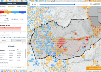
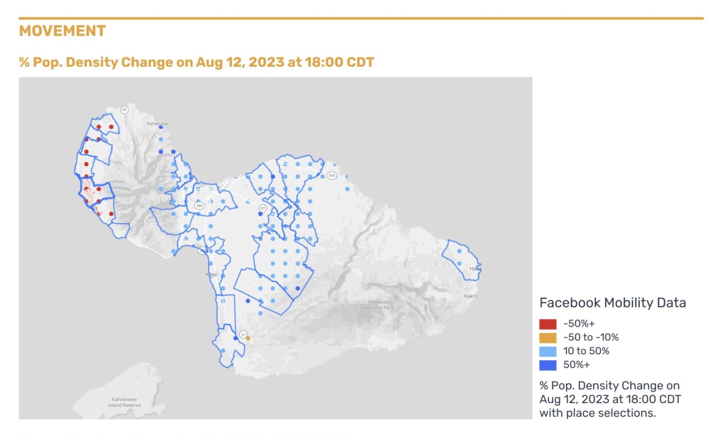
Saturday, August 12, 2023
Monday, August 14, 2023
Hawaii | 18:00 CDT (7:00 p.m. local time)
This report provides information on population density changes registered on Monday, August 14 at 18:00 CDT (7:00 p.m. local time) in the regions of Hawaii most affected by the wildfires.*
The report also provides information on baseline community vulnerabilities and local health care infrastructure.
Key Observations
Death Toll & General Updates:
- 99 confirmed deaths as of Tuesday, August 15.
- Rescue and identification efforts are ongoing.
- Upcountry/Kula fire is about 65% contained.
- The Lahaina fire is 85% contained.
Decreases in Population Densities:
- As of August 14, mobility data from Data for Good continues to show significant decreases in population densities in various regions of Maui.
- In Western island areas including Kapalua, Mahinahina, and Napili-Honokowai:
- Population density remains decreased compared to pre-fires levels.
- Slowly returning to baseline levels.
- Return of people to those locations or the arrival of new populations, such as first responders, may be occurring but are not yet confirmed.
- In Launiupoko, Kaanapali, and Lahaina:
- Population densities have decreased between 50% – 92% compared to pre-crisis levels.
- This remains consistent with previous observations.
Increases in Population Densities:
- Ongoing increases in population densities near the most affected areas, but some areas are trending slowly toward baseline.
- Maalalaea and Waikapu, between the Lahaina and Upcountry Maui/ Kula fires:
- Currently have population densities that are 30% – 40% above baseline levels.
- These are trending to normal, pre-fire levels.
- Areas east of the Upcountry Maui and Kula, including Pukalani, Haliimaile, and Kula:
- Continue to have population densities above baseline levels.
- Currently, these areas are moving toward normal population levels with densities less than 20% relative to baseline.
*Please note: The data reflects 8% to 21% of the population in the affected areas who have active location services, so it provides a snapshot rather than a complete picture of the mobility patterns.
Saturday, August 12, 2023
Hawaii | 18:00 CDT (7:00 p.m. local time)
This report provides information on population density changes registered on Saturday, August 12 at 18:00 CDT (7:00 p.m. local time) in the regions of Hawaii most affected by the wildfires.*
The report also provides information on baseline community vulnerabilities and local health care infrastructure.
Key Observations
Death Toll & Causes:
- 96 confirmed deaths and over 1,000 people reported missing.
- Causes include drought, high winds, and downed power lines.
Decreases in Population Densities:
- Significant decreases in population densities in western areas such as Napili-Honokowai, Kapalua, Mahinahina, Launiupoko, Kaanapali, and Lahaina.
- Decreases range from 56% to 95% compared to pre-crisis levels.
- 15% to 38% of the population in these areas are older than 65 years.
Increases in Population Densities:
- More than 34% increase in areas such as Waikapu, Wailuku, Maalaea, Waihee-Waiehu, and Kahului.
- Smaller increases of less than 34% near the Upcountry and Kihei fire perimeters in the island’s center.
- Shelters have been opened in various locations, including Kahului, Kihei, Makawao, Pukalani, and Mailuku, as reported by local news sources.
*Please note: The data reflects 8% to 21% of the population in the affected areas who have active location services, so it provides a snapshot rather than a complete picture of the mobility patterns.
Thursday, August 10, 2023
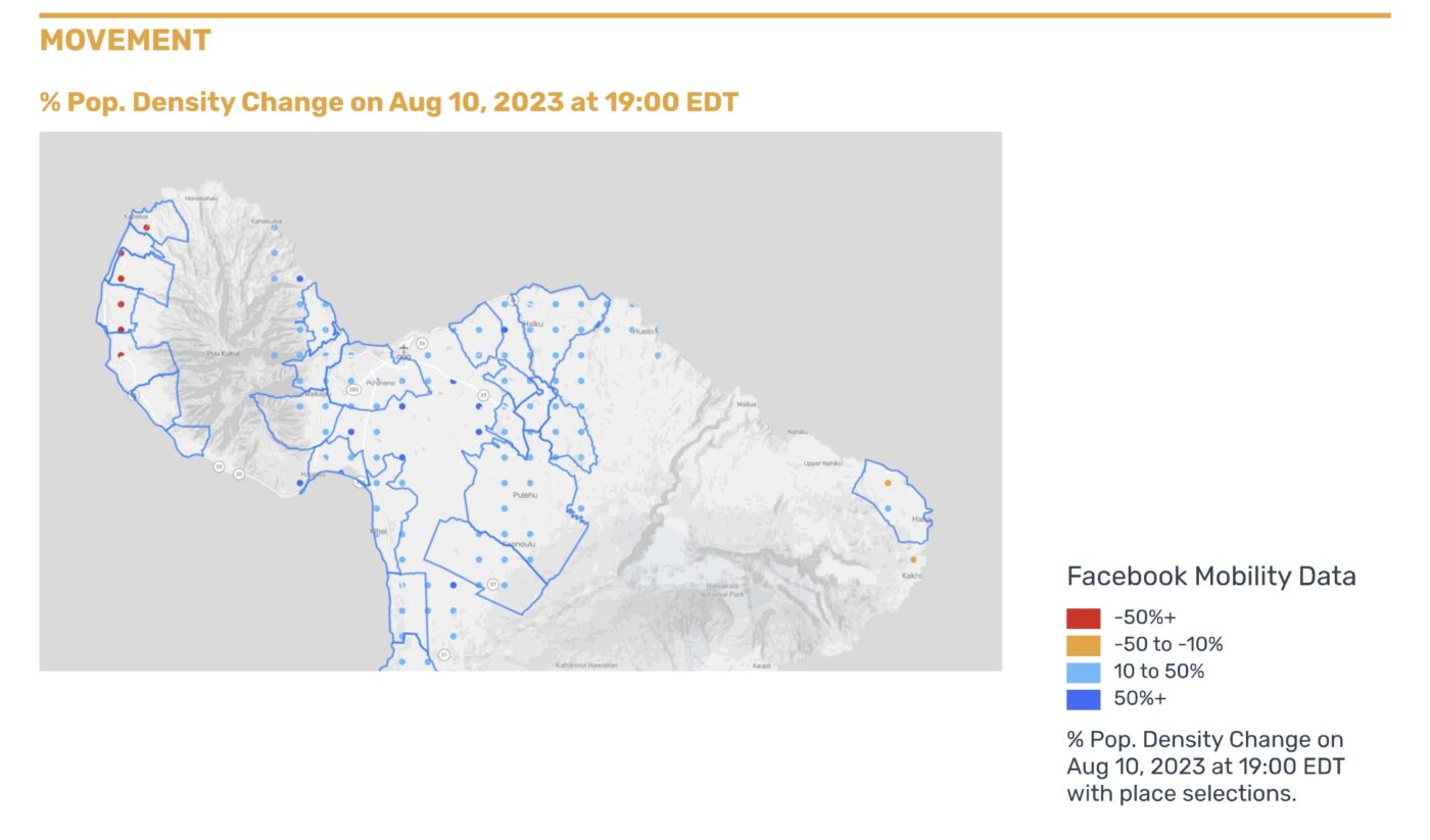
Hawaii | 7:00 p.m. local time
This report provides information on population density changes registered on Thursday, August 10 at 18:00 CDT (7:00 p.m. local time) in Hawaii.*
The report also provides information on baseline community vulnerabilities and local health care infrastructure.
Key Observations
- 55 people have been killed as of August 11, 2023.
- Population densities along the western shores of Maui have decreased by 84% to 99%.
- The greatest population decreases occurred in Lahaina, Kaanapali, Kapalua, and Mahinahina.
- There have been increasing population densities in Kahului, where most shelters have been opened, as well as in Wailuku and Waihee-Waiehu to the north of Kahului.
*Please note: The data reflects 8% to 21% of the population in the affected areas who have active location services, so it provides a snapshot rather than a complete picture of the mobility patterns.