CrisisReady researchers have published a new peer-reviewed study examining how leading AI models perform at one of the most urgent tasks in disaster response: rapidly identifying damage to health facilities. The paper, “Implementation of remote-sensing models to identify post-disaster health facility damage: Comparative approaches to the 2023 earthquake in Turkey,” appeared in PLOS Digital Health on October 27, 2025, authored by Dr. Anu Ramachandran, Akash Yadav, and Andrew Schroeder.
The challenge
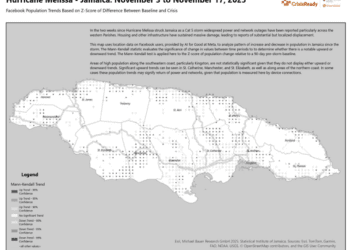
When the February 2023 earthquakes struck southern Turkey and northern Syria, one of the highest priorities was understanding the extent of damage across every level of the health system — not only hospitals, but the clinics, pharmacies, and dialysis centers that communities depend on. Traditional ground-based assessments are accurate but slow, often taking weeks to complete, and lower-level facilities frequently wait far down the priority queue. Those delays limit how quickly responders can plan for replacement capacity and long-term rebuilding.
AI models trained on satellite imagery offer a promising shortcut, generating rapid building-damage estimates from remotely sensed imagery. But until now, little has been published about how these estimates are generated, how accurate they are in real-world settings, or where their errors come from.
What the study did
The research takes a comparative approach to two of the most prominent models used during the 2023 response: a Microsoft neural network model and a Google AI model. The team overlaid each model’s building-level damage outputs with the locations of three types of health facilities — hospitals, dialysis centers, and pharmacies — to generate facility-level damage estimates, then evaluated the models for agreement, accuracy, sensitivity, specificity, and common sources of error.
What they found
It proved feasible to combine these data sources to produce rapid health facility damage reports. However, the two models calculate damage in significantly different ways — using different measures, methods, and area polygons — and sensitivity was low for the specific health facilities evaluated. In other words, the models went a long way toward providing a fast, clear view of health system damage, but their differences and limitations need to be understood before their outputs can be trusted as an ensemble.
The authors point to concrete paths forward: improving building identification, strengthening detection of fully destroyed buildings, and spatially aggregating results to improve both the accuracy and usability of these models in operational disaster settings.
Why it matters
As rapid remote assessment becomes increasingly central to humanitarian health response, this work helps define the research agenda for what still needs to be solved. It is a step toward a future where responders can move from satellite imagery to actionable health system intelligence in hours rather than weeks.
This research was conducted by CrisisReady in partnership with Direct Relief, with collaborators from Stanford University and the VA Palo Alto Health Care System.
Read the full open-access paper in PLOS Digital Health: https://journals.plos.org/digitalhealth/article?id=10.1371/journal.pdig.0001060