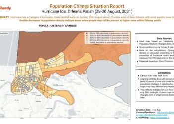
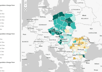
Summary: The interactive map below shows changes in population densities and refugee reception points along the Poland-Ukraine border as of March 7, 2022.
Data Sources: This map was generated using human mobility data gathered from Meta’s Data for Good initiative and border checkpoint information from HDX.
Note: To interact with the map below, click and drag the time selection tool. Information relating to the selected timeframe will be displayed above the time selection tool. Users may also move the map by clicking and dragging your cursor until the desired region is shown. Users may disable 3D mapping visualization, access the legend, draw a specific region on the map, or change the language by clicking the widgets displayed in the upper right hand corner.
Interactive Map: Changes in Population Densities Along the Poland-Ukraine Border
Learn More
Follow Us on Social Media